
Sattva Varthur Road Masterplan
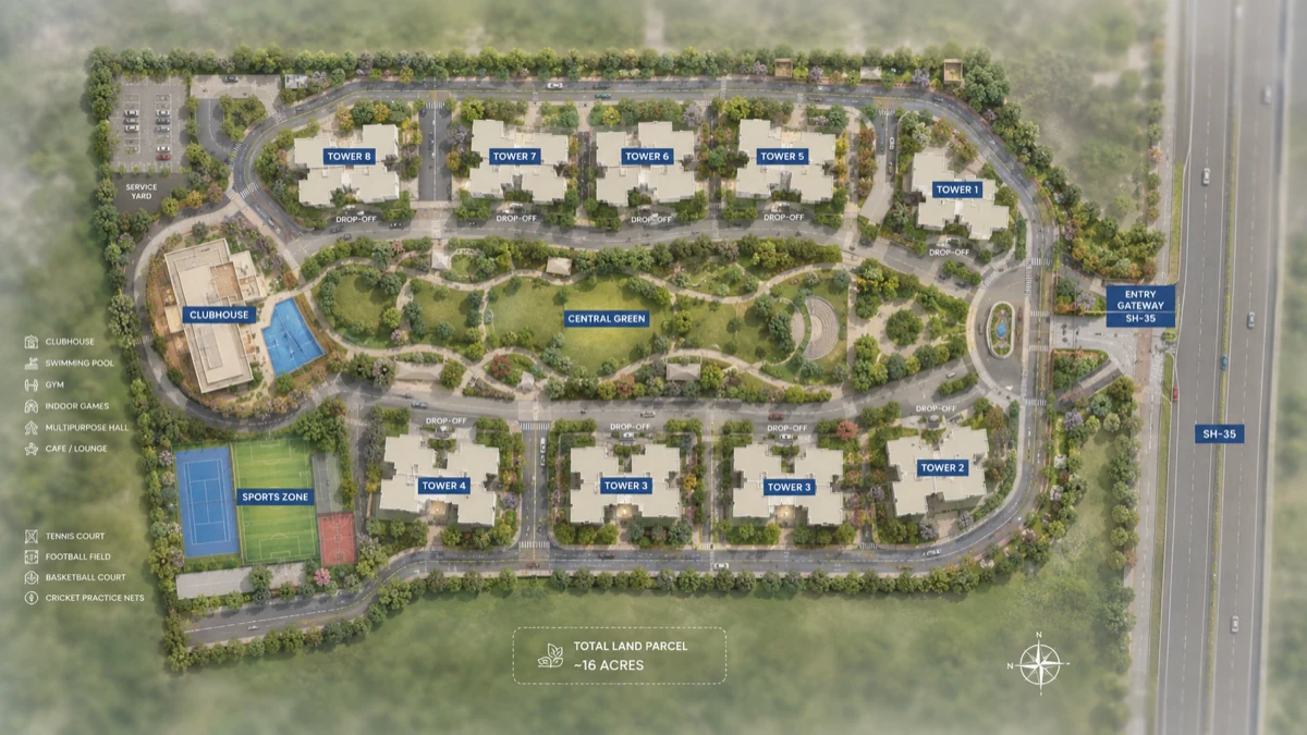
Approximately 16 acres at Dommasandra organised into a single internally-walkable community of 8 towers, a central amenity and green spine, a peripheral vehicular loop, and a fully covered three-level basement — with more than 70% of the site at grade left open for landscape, amenities and circulation. For another Bengaluru planning reference, Sattva Whitefield helps keep attention on density, circulation, landscape depth, and the way residents will move through the community.
Sattva Varthur Road site design overview
Sattva Varthur Road organises approximately 16 acres at Dommasandra, on the SH-35 Varthur–Sarjapur Road frontage, into a single internally-walkable high-rise community of 8 towers, a central amenity and green spine, a peripheral vehicular loop, and a fully covered three-level basement. Because the 1,363 apartments are stacked vertically to a 3-basement, ground, plus 33-upper-floor (3B+GF+33) configuration, the ground plane is freed up: more than 70% of the site at grade is left unbuilt for landscape, amenities, and circulation.
Land use breakdown
The master plan of Sattva Varthur Road is built around a simple principle — build tall on a small footprint, then give the rest of the site back to open space. Eight slender towers occupy roughly a fifth of the plot at grade; the balance is landscape, amenity, circulation, and reserved open space.
| Component | Approx. share of site | Notes |
|---|---|---|
| 8 residential towers (ground footprint) | ~20% | Slender floor plates, ~5 units per floor per core |
| Clubhouse and amenity blocks | ~4% | Central, anchoring the social spine |
| Internal roads, driveways, drop-offs | ~9% | Peripheral loop with basement ramp access |
| Sports courts, pool decks, kids' play | ~9% | Distributed through the central and edge zones |
| Landscape, central green spine, tracks | ~40% | Edge-to-edge planting and walking circulation |
| BDA park / civic amenity reservation | ~10% | Reserved open space per layout sanction |
| Utility zone (STP, WTP, DG, transformer, OWC) | ~3% | Screened, at the site edge |
| Entry plaza and perimeter setback buffers | ~5% | Frontage buffer to SH-35 and boundary setbacks |
Built footprint at the ground plane — towers, amenity blocks, and utility structures — works out to roughly a quarter of the site, leaving open space of over 70%. Of that open area, close to half the total site is soft landscape and reserved green, which is the number that gives the campus its porosity. With 1,363 homes on 16 acres, the density of about 85 units per acre is delivered by height, not by ground coverage, which is precisely what keeps the surface generous.
Building placement strategy
Eight towers of ground-plus-33-floors are a lot of vertical mass to arrange on 16 acres without the towers shading or overlooking one another. The placement strategy resolves this by ringing the towers around the periphery of the plot and holding the centre open as a landscaped green spine.
Perimeter towers, central green. The eight cores are set toward the edges of the site so that the middle is preserved as an uninterrupted landscape and amenity zone. Every tower therefore fronts onto open green rather than onto another tower's base, and residents move from lobby to landscape without crossing the vehicular loop.
Generous inter-tower spacing. A 3B+G+33 tower stands above 100 metres, and high-rise separation is governed by fire-service access and daylight rules. The towers are spaced well apart — on the order of 20 to 30 metres between faces — so that daylight reaches the lower floors, natural ventilation is not blocked, and fire-tender movement around each core is unobstructed. This spacing is only affordable because the floor plates are slender and the footprint is small.
Orientation for light and cross-ventilation. Each tower is turned so that its long axis catches the prevailing breeze and its habitable rooms — living and bedrooms — open toward the central landscape and away from the harshest west sun and the SH-35 road edge. With about five units per floor around an efficient core, most apartments are corner or through units, which is what makes genuine cross-ventilation possible rather than nominal. The ~170 homes per tower are stacked over 33 floors on this compact, well-lit plate.
Frontage buffer. The SH-35 frontage is held back behind an entry plaza and a planted setback buffer, so the towers do not sit hard against the arterial. This buffer does double duty as the project's address gateway and as an acoustic screen against corridor traffic.
Green belt and open-space design
The open space at Sattva Varthur Road is not leftover land between buildings — it is the organising element of the plan. Roughly 40% of the site is soft landscape and walking circulation, and a further ~10% is held as BDA-mandated park and civic-amenity reservation, so close to half the total site reads as green. The landscape is layered in three bands:
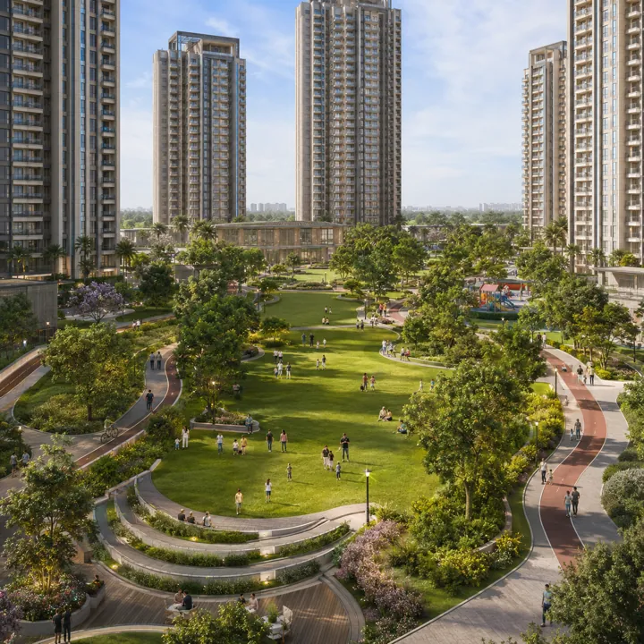
- The central green spine. The heart of the site, ringed by the eight towers, is kept as a continuous landscaped commons — lawns, tree groves, seating courts, and the amenity decks — that every tower faces. This is the campus's lung and its social centre.
- The amenity green. Around the clubhouse and pool decks, the landscape is programmed — shaded plazas, children's play areas, senior-citizen courts, and multipurpose lawns — so that the open space is used, not just looked at.
- The perimeter belt. The outer edge of the plot along all boundaries is planted as a green buffer, thickest along the SH-35 frontage where it screens the towers from arterial noise and headlight glare. Walking segments threaded through this belt feel like garden paths rather than apartment commutes.
Because the built footprint sits at roughly a quarter of the site, this green structure has real depth rather than being a token strip. The reserved BDA park area is additive to the private landscape, not carved out of it.
Road and circulation network
Vehicular and pedestrian movement at Sattva Varthur Road are deliberately separated. Cars are kept to a peripheral loop and pushed underground as quickly as possible; the interior is for people.
- Entry and exit from SH-35. The campus takes controlled access off the SH-35 Varthur–Sarjapur Road frontage at the Dommasandra Circle end, through a gateway plaza with a boom-barrier and security cabin. Consolidating access to the frontage keeps the internal circulation legible — one arrival sequence, one exit.
- Peripheral driveway loop. A driveway loop runs around the inner core, connecting the eight tower drop-off lobbies and feeding the basement ramps. The loop does not cross the central landscape or the amenity decks, so pedestrians never share the surface with moving vehicles.
- Basement ramps. Multiple ramps take vehicles down into the three-level basement close to the entry, so cars leave the surface quickly rather than circulating at grade. Entry and exit ramps are separated to avoid cross-traffic conflict.
- Fire-tender access. The peripheral loop and inter-tower gaps are dimensioned to provide clear fire-tender movement to every tower base, in line with Karnataka Fire Services requirements for high-rise structures.
- Service and waste routing. Service vehicles, move-in trucks, and waste collection are routed to the utility zone at the site edge, away from the residential lobbies and the amenity core.
- Drop-offs. Each tower has a sheltered drop-off at its lobby, so residents and visitors alight under cover before the vehicle proceeds to the basement or exits.
Because parking is fully absorbed below ground, the surface driveway is a thin loop rather than a sprawling parking field — which is what allows the central 40%-plus of the site to stay planted.
Pedestrian movement and landscaping
Pedestrian movement is grade-separated from the vehicular loop across the whole campus. Once a resident is out of the basement lift or the tower lobby, the entire interior — the green spine, the clubhouse, the pool decks, the play areas — is reachable on foot without crossing a driveway. The pedestrian network is laid out as concentric bands:
- The amenity spine. A landscaped pedestrian plaza links the eight towers to the clubhouse, the swimming pool, and the children's play zones. This is the social artery of Sattva Varthur Road, and it runs entirely through the traffic-free centre.
- The exercise loop. A jogging and walking circuit — on the order of a kilometre once it threads the central and perimeter landscape of a 16-acre site — loops the inner amenity zone, supplemented by a reflexology pathway and separate cycling and children's tricycle tracks laid at safe gradients.
- The garden edge. The outermost band along the boundaries is a planted walking belt, where the walking segments feel like garden strolls under the perimeter tree canopy.
Landscaping is used both for amenity and for microclimate. Tree groves along the western and road-facing edges cut afternoon heat gain and arterial noise; shaded courts and pergolas keep the amenity decks usable through the day; and the continuous soft ground helps the rainwater-harvesting system by letting surface runoff percolate rather than sheet off hardscape.
Below-ground infrastructure
The three-level basement is the piece of engineering that makes the open surface possible. All three levels — Basement 1, Basement 2, and Basement 3 — run as fully covered parking and services for the entire community, accessed through separated entry and exit ramps at gentle gradients suited to sedan and SUV clearance. The basement absorbs parking for the full resident and visitor load — on the order of 2,000-plus car bays across the three levels for the 1,363 apartments — which is why the surface carries only a thin driveway loop and drop-offs rather than a parking field. Beyond car parking, the basements house the community's mechanical and water infrastructure:
- Sewage Treatment Plant (STP) — sized for the full 1,363-unit peak load, on the order of 1 MLD, with treated water returned to the campus for flushing and landscape irrigation.
- Rainwater harvesting tanks and recharge structures — capturing roof and surface runoff for storage and groundwater recharge.
- Domestic water tanks, the Water Treatment Plant feed, and pump rooms — conditioning and lifting water to the overhead tanks across all eight towers.
- Fire-fighting tanks and pump rooms — meeting Karnataka Fire Services Department requirements for a high-rise of this height.
- Electrical rooms, BESCOM transformer feeds, and DG (diesel generator) rooms — for common-area and backup power.
- Cable trenches, ventilation shafts, and common utility storage.
Mechanically noisy or waste-handling elements — the transformer yard, the DG yard, and the organic-waste converter — are clustered at the site edge behind planted screening, keeping the residential cores and the central landscape free of mechanical noise.
Sustainability infrastructure
Sattva Varthur Road is engineered to be substantially self-reliant on water, because piped BWSSB/Cauvery supply is still limited this far along the Sarjapur corridor. The master plan integrates a closed-loop water strategy alongside energy-efficiency measures.
- STP with dual plumbing. The on-site STP, sized on the order of 1 MLD for the full 1,363-unit peak load, feeds a separate (dual) plumbing network so that treated water is reused for toilet flushing, landscape irrigation, and common-area washing — cutting fresh-water demand across the campus.
- Water Treatment Plant (WTP). Incoming borewell and tanker water is conditioned to potable standard by an on-site WTP before it enters the domestic supply, insulating residents from the variable quality of raw source water.
- Rainwater harvesting. Recharge wells and percolation pits distributed across the landscape capture roof and surface runoff, replenishing the water table and reducing tanker dependence. The high proportion of soft ground on site directly supports percolation.
- Solar common-area lighting. Solar-assisted lighting serves corridors, basements, landscape, and the perimeter, trimming the monthly maintenance load carried by residents.
- Energy-efficient envelope and services. High-performance glazing, LED lighting, and efficient common-area equipment target the performance benchmarks of the Energy Conservation Building Code (ECBC), lowering operational energy draw.
- Organic-waste converter (OWC) and segregated waste. On-site organic-waste processing and segregated solid-waste collection reduce the community's waste-to-landfill footprint.
The combined effect of the closed water loop, the harvesting network, and the solar and efficiency measures is a campus designed to run on a lower per-flat monthly water and energy bill than a comparably sized community dependent on municipal supply.
Building specifications summary
| Total land area | ~16 acres |
| Towers | 8 |
| Tower configuration | 3 Basement + Ground + 33 upper floors (3B+GF+33) |
| Total apartments | 1,363 |
| Density | ~85 units per acre (~170 per tower) |
| Open space at grade | Over 70% |
| Parking | 3-level basement, ~2,000+ covered bays |
| Configurations | 1, 2, 3 (2-toilet), 3 (3-toilet), 4 BHK + servant |
| Super built-up range | 600 – 2,310 sq ft |
| Water source | Borewell + tanker, conditioned by WTP; STP recycle and RWH |
| Sewage | On-site STP (~1 MLD), treated-water reuse via dual plumbing |
| Common-area lighting | Solar-assisted |
| Waste management | OWC + segregated solid-waste collection |
| Pedestrian movement | Grade-separated from vehicular loop |
| Approving authority | BDA-approved layout; not yet RERA-registered |
The master plan does what disciplined high-rise urban design should do — it concentrates the built mass vertically, absorbs the cars underground, and hands the surface back to landscape. The result is a 16-acre campus that lives larger and greener than its footprint, with the water and energy infrastructure to run reliably on a corridor where municipal supply is still catching up.
See the Sattva Varthur Road master plan
Request the detailed site layout, tower placement and phasing plan, and speak with a consultant about tower and floor choice.
Sattva Varthur Road Master Plan - Frequently Asked Questions
The master plan organises approximately 16 acres into a single internally-walkable high-rise community of 8 towers, a central amenity and green spine, a peripheral vehicular loop, and a fully covered three-level basement. Because the 1,363 apartments are stacked vertically to a 3B+GF+33 configuration, more than 70% of the site at grade is left unbuilt for landscape, amenities and circulation.
The built footprint at grade — towers, amenity blocks and utility structures — works out to roughly a quarter of the site, leaving open space of over 70%. Close to half the total site is soft landscape and reserved green: roughly 40% is landscape and walking circulation, plus about 10% held as BDA-mandated park and civic-amenity reservation.
The eight cores are ringed around the periphery of the plot with the centre held open as a landscaped green spine, so every tower fronts onto open green rather than another tower's base. The towers are spaced well apart — on the order of 20 to 30 metres between faces — for daylight, ventilation and fire-tender access, and each is oriented to catch the prevailing breeze with habitable rooms facing the central landscape.
Parking is fully absorbed into a three-level basement — on the order of 2,000-plus covered car bays across the three levels for the 1,363 apartments — accessed through separated entry and exit ramps at gentle gradients. Pulling parking below grade is what allows the surface to carry only a thin driveway loop and drop-offs rather than a parking field.
Vehicular and pedestrian movement are deliberately separated. Cars are kept to a peripheral driveway loop and pushed underground close to the entry, so the loop never crosses the central landscape or amenity decks. Once out of the basement lift or tower lobby, the entire interior — green spine, clubhouse, pool decks and play areas — is reachable on foot without crossing a driveway.
A closed-loop water strategy runs an on-site sewage treatment plant (around 1 MLD) feeding a dual-plumbing network for flushing and irrigation, a water treatment plant conditioning borewell and tanker water, rainwater harvesting with recharge wells, solar-assisted common-area lighting, an ECBC-oriented energy-efficient envelope, and an organic-waste converter with segregated waste collection.